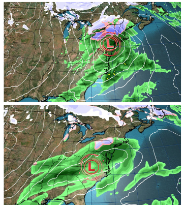
A powerful storm combined with the coldest air of the season is set to create Thanksgiving travel chaos across the eastern half of the United States. The storm will sweep through the Midwest and South on Wednesday night, spreading into the East on Thanksgiving Day, accompanied by a surge of winterlike chill.
The storm’s track remains uncertain, with two primary scenarios at play. In the first scenario, a stronger, faster-moving storm develops in the Plains and strengthens as it heads east. It could bring heavy rain from the Midwest to the South before turning northeast along the Appalachians, delivering heavy, wet snow to elevated areas of the interior Northeast and gusty winds across the East. Wind speeds could reach up to 30 mph, with higher gusts along the coast, potentially causing power outages and travel disruptions.

In the second scenario, a weaker, slower storm develops late Wednesday around the Mississippi or Tennessee valleys. It would bring widespread rain to the Southeast and mid-Atlantic, with limited chances for snow in the Northeast. Post-holiday travel could also be impacted Friday, depending on how close the storm tracks to the Atlantic coast.
Regardless of the storm’s path, a blast of cold Canadian air will grip much of the U.S. starting Thursday, with temperatures plunging well below normal. Cities like Chicago and Philadelphia could see highs in the mid-30s, with parts of North Dakota barely reaching the teens. The Great Lakes will also experience lake-effect snow due to the influx of cold air over warm waters.
The chill will linger into the weekend and could persist into early December, bringing widespread winterlike conditions across the central and eastern U.S.


